 This window presents some statistical associations between the Atlas
findings of species occurrence and natural and environmental factors.
This window presents some statistical associations between the Atlas
findings of species occurrence and natural and environmental factors.
Background on the analyses are given in another section (see the Statistical exploration in the Methods section). While reviewing these paragraphs and diagrams, keep in mind that these are statistical associations, not proofs that particular variables are causing a species to be present or absent during the breeding season.
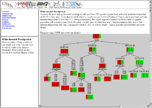
The analysis consists of a written description followed by Classification Tree diagrams. Scroll in the analysis window to view the diagrams.
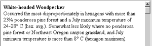 The first part of the paragraph describes results of the Classification
Tree Analysis for the species, based on the ONHP land cover data and the
climate data and analyzed at the hexagon scale. The most
statistically-significant associations are described first.
Each of the numeric categories of a variable (e.g., annual
precipitation split into groups of 5-12 mm, 13-92 mm, and 93-98 mm)
for a species is statistically significant. When given, the endpoints
(e.g., 5 to 98 mm) bracket the range of that variable over which the
species was found to occur significantly during the breeding season in Oregon.
Additional detail on such endpoints is provided in the tree diagrams. However,
numbers in the diagrams may not agree with the text because mathematical
transformations were sometimes applied.
The first part of the paragraph describes results of the Classification
Tree Analysis for the species, based on the ONHP land cover data and the
climate data and analyzed at the hexagon scale. The most
statistically-significant associations are described first.
Each of the numeric categories of a variable (e.g., annual
precipitation split into groups of 5-12 mm, 13-92 mm, and 93-98 mm)
for a species is statistically significant. When given, the endpoints
(e.g., 5 to 98 mm) bracket the range of that variable over which the
species was found to occur significantly during the breeding season in Oregon.
Additional detail on such endpoints is provided in the tree diagrams. However,
numbers in the diagrams may not agree with the text because mathematical
transformations were sometimes applied.
For easier reading in the written descriptions of the trees, we expressed some of the areal measurement units as percents (% of total area of each hexagon). For simplicity sake, we also used the term "topographic variation" (or "varied topography" or "varied terrain") instead of saying "spatial standard deviation of the monthly temperature" (or monthly precipitation), which in some cases was the variable that actually was measured, and which typically is correlated with topographic variation.
Also included are classification trees resulting from hexagon-scale analysis using an alternative (AVHRR) habitat data set. These trees are not described narratively on this CD. Similarly, classification trees from analysis at the square scale using ONHP habitat data are provided but have not been written up.
 The second part of the paragraph describes results of the Logistic Regression
Analysis. The first set of variables are those with highly significant
Wald-Z values (a measure of statistical significance), whereas those preceded
by the phrase, "and to a lesser extent" are those with smaller
(but still significant) Wald-Z values. Within these two groupings,
the significant variables are listed in no particular order.
Variables were listed if they were found to be statistically
significant either when all 430 hexagons were considered, or when just
the hexagons that have at least 41% of their land area in Oregon
(a significant break point for species richness) were considered.
Although some "effort" variables (observer hours, number of observers,
observation years, percent of hexagon in Oregon) were statistically
significant, they are not reported in these narratives.
The second part of the paragraph describes results of the Logistic Regression
Analysis. The first set of variables are those with highly significant
Wald-Z values (a measure of statistical significance), whereas those preceded
by the phrase, "and to a lesser extent" are those with smaller
(but still significant) Wald-Z values. Within these two groupings,
the significant variables are listed in no particular order.
Variables were listed if they were found to be statistically
significant either when all 430 hexagons were considered, or when just
the hexagons that have at least 41% of their land area in Oregon
(a significant break point for species richness) were considered.
Although some "effort" variables (observer hours, number of observers,
observation years, percent of hexagon in Oregon) were statistically
significant, they are not reported in these narratives.
Precipitation and temperature values for the months April-July were available from modeled data (PRISM model) for up to 44 cells within each hexagon. In our statistical analysis of species distributions, we used the spatial average (hex. avg.), spatial median (hex. med.), spatial minimum (hex. min.), and spatial maximum (hex. max.) of the values from these cells as independent variables. We stress that these are spatial, not temporal, summaries.